Main Information
LCI: JPN1607131159
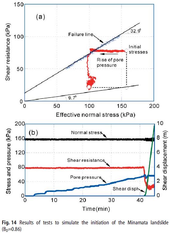
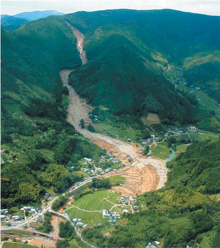
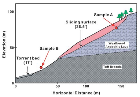
On 20 July 2003, a landslide occurred in an andesitic weathered lava layer on a mountain slope of 31–32 degrees in Minamata City, Kumamoto Prefecture, Kyushu Island, Japan. It was triggered by a heavy rainstorm with 314 mm total rainfall and a maximum rate of rainfall of 91 mm/h. The slide mass entered a torrent, where it was transformed into a debris flow that struck a village along the torrent, destroying 15 houses, killing 15 people, and injuring an additional six people. This debris flow was triggered by the slide, and the landslide mass flowed downstream along the torrent, increasing its volume by entraining material from the channel and weathered surface soils of the mountain slopes on both sides of the channel. Based on a topographic survey made after the landslide occurred, the initial slide was estimated to have occurred along a failure surface with an inclination of 26.5 degrees and depth of approximately 10–12 m. Source: Sassa, K., Fukuoka, H., Wang, G. et al. Undrained dynamic-loading ring-shear apparatus and its application to landslide dynamics. Landslides (2004) 1: 7. doi:10.1007/s10346-003-0004-y
Location
City / District: Minamata
Province: Kumamoto
Country: Japan
Latitude: 32:12:40 N
Longitude: 130:25:33 E
Reporter
Reporter 1: Khang Dang
Reporter 2: Kyoji Sassa
Landslide Type
Material: Debris
Movement: Flow
Velocity (mm/sec): Extremely Rapid (5×10³ or more)
Depth (m): Moderate-Shallow (5 - 20)
Slope (degree): Moderate (20 - 30)
Volume (m³): Unknown
Date of Occurence
Date of Occurence: 01/20/2003
Other Information
Land use (Source Area): Forest
Land use (Run-out/deposition area): Farming, Road
Other Activity: Active in the past
Triggering Factor: Rainfall
Death(s) & Missing: 15
Houses and other structural damage: 15
Photo of landslide
Google earth kmz file
Plan of landslide
Cross section of landslide
Reference (paper / report) (Insert link)
Testing graph